Last Updated 9/3/2017
added 9/3/2017
Background:
Elmer’s states the following in their presentation:
We measured the noise volumes of our portable gravel plant and construction equipment operating on August 1, 2017 at a customer’s gravel pit at multiple distance intervals. The gravel pit is flat and has no screening.
- 100 feet: 77 to 78 decibels. This is comparable an enclosed cab tractor.
- 500 feet (MSHA minimum distance from residences): 59-64 decibels. This is comparable to normal conversation.
- 1000 feet (expected actual distance from residences): 45 to 64 decibels. This is comparable to raindrops and normal conversation.
Question:
The following audio was taken from over 2000 feet away from the Manthei gravel pit. The audio was not increased or changed in any way and taken with an iPhone on 8/28/2017 at 10:12 AM. Does this sound like rain drops? Keep in mind this is over 1000 feet greater than what Elmer’s out of Traverse City is calling comparable to raindrops.
added 8/24/2017
Background:
Elmer’s states the following in their presentation: “The American Association of State Highway Transportation Officials (AASHTO) recommends 495 feet of sight distance for stopping at 55 mph. Our proposed entrance provide twice that sight distance in either direction.”
Question:
If you are applying for a special use permit in Emmet County, why wouldn’t you check the Emmet County Road Commission recommendations since you plan to apply for a “commercial” driveway.
Under section 1-3 “Specifications and Design Standards”, for commercial driveways, look at Table 1-2. The sight distance required for a commercial driveway on a road that is 55mph would be 650 feet. ref: Emmet County Road Commission Driveway & Miscellaneous Permits.
added 8/18/2017
Background:
Need. In the Elmer’s presentation the following was stated: “We expect to haul 25,000 tons annually from this resource”.
Question:
The need for gravel is stated as 25,000 tons annually. According to Randy Schaetzl, Professor of Geography at Michigan State University, he states the following: “Construction of one mile of four-lane interstate highway requires 85,000 tons of aggregate; the average six room house requires 90 tons. “Aggregate” is any of several hard inert materials (as sand, gravel, or slag) used for mixing with a cementing material to form concrete, mortar, or plaster.”
ref: http://geo.msu.edu/extra/geogmich/sand&gravel.html
Let us go back to the Elmer’s presentation. Annually they will haul 25,000 tons. If we take the information above, 85,000 tons for 4 miles (one mile of four-lane interstate), we get an average of 21.25 tons for 1 mile of road. We can only conclude from the presentation and the facts above that the need is approximately the equivalent of 1 mile of interstate annually.
When you look at the revised site plan below that we created and the date provided that they plan to go 20 FT in depth, one is left questioning the “need” for gravel. The special permit is for the extraction of gravel.
added 8/18/2017
Background:
The Elmer’s presentation does not mention the danger of “Heavy Trucks” when they spoke about “Community Impact”.
Question:
Will these 100 gravel trucks per day cause severe consequences to the residents along these proposed routes?
We will just reference the “National Highway Traffic Safety Administration”. They say the following:
“Heavy vehicles include trucks and buses with a Gross Vehicle Weight (GVW) rating of 10,000 pounds or more. These vehicles represent a significant safety challenge for NHTSA, the commercial vehicle industry, and for our Nation. 4,000 fatalities and over 400,000 police-reported crashes involving heavy vehicles occur each year.”
ref: https://www.nhtsa.gov/research-data/crash-avoidance#heavy-vehicles
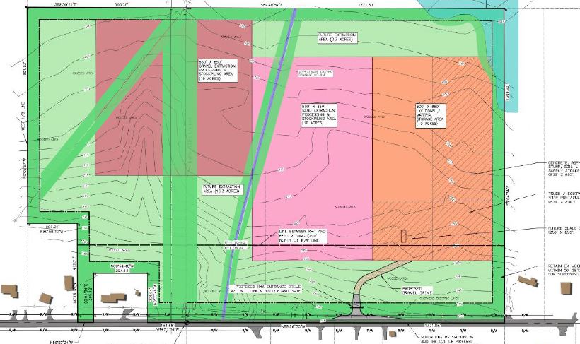
Updated 8/29/2017
Background:
Team Elmers provided the following site map in their presentation to Emmet County:
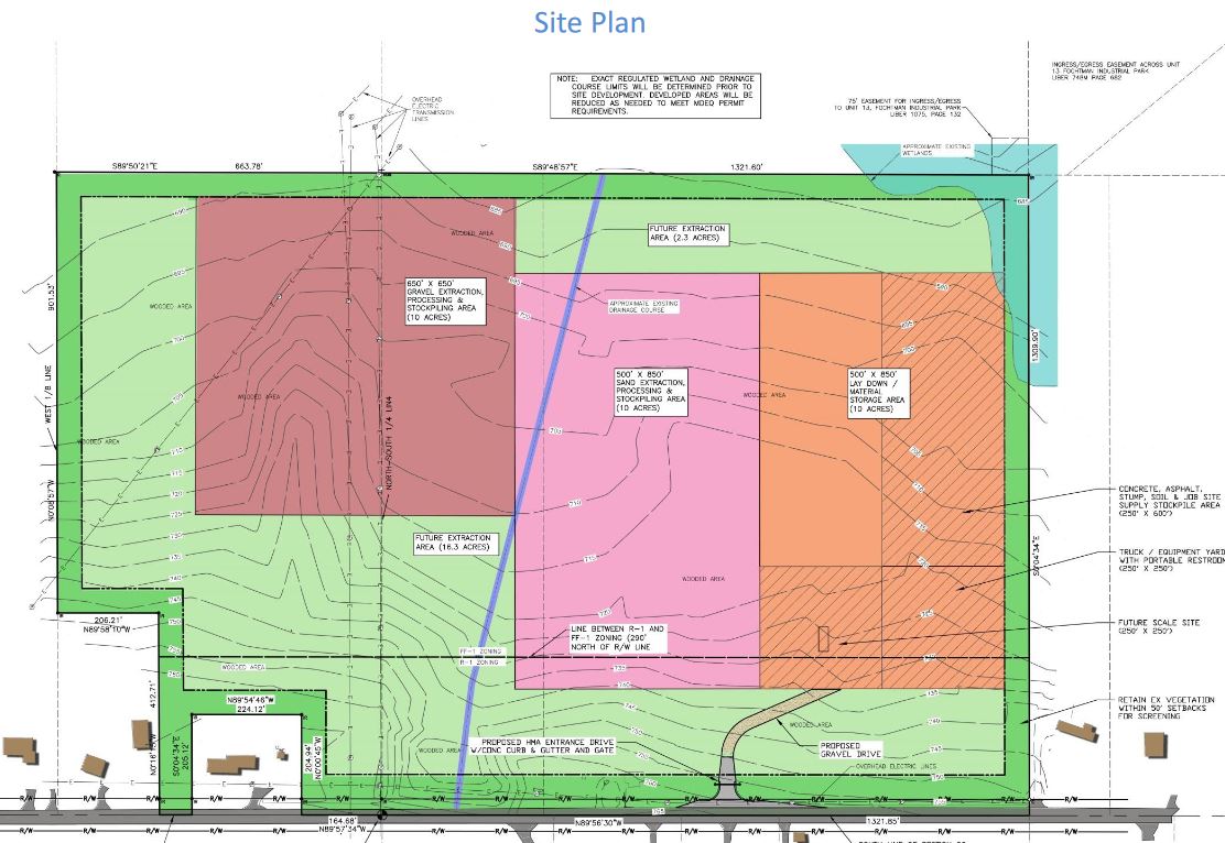
Question:
If the 50 FT setbacks were defined by the darker green around the perimeter, why weren’t the 50FT utility easements show in dark green as well? In addition, why wasn’t the 60FT waterfront setback defined in section 22.11.2 of the Emmet Zoning Ordinance placed on the site map or even discussed in the presentation?
The following picture has not been drawn by a professional or drawn to scale, it is displayed just for reference. However, the site map should probably look more like the following (Not including the setback of the wetlands on the North East corner:
USGS Map
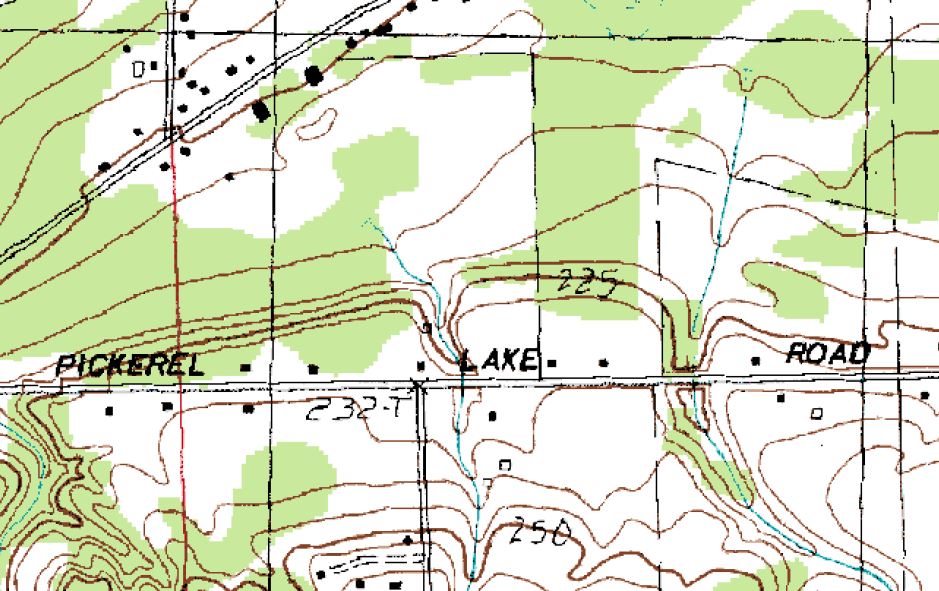
added 8/8/2017
Background:
Team Elmers provided the following Hydrogeolotic Evaluation of the proposed Elmer’s Gravel Mine which was performed by Otwell Mawby in Traverse City.
Review of the USGS Topographic Map for the area indicates a topography sloping downward in a northerly direction with eventual drainage to Round Lake and then eventually to Little Traverse Bay. We did not review specific information with regard to groundwater flow in the area but regional groundwater flow is in a northwesterly direction towards Round Lake and Little Traverse Bay /Lake Michigan. There could be localized groundwater hydrologic flow scenarios in the upper soil profile due to the complicated geology but give the topography in the vicinity of the site and the location of Little Travers Bay, the regional aquifer flow would be in the westerly direction away from Pickerel Lake Road. Gravel mining operations would be in a down-gradient direction from Pickerel Lake Road and are not expected to affect the groundwater quality of the Pickerel Lake Road wells.
Question:
Does Round Lake eventually drain into Little Traverse Bay / Lake Michigan?
No. The Pickerel-Crooked Lakes Watershed can be broken down into a group of subwatersheds, all of which eventually flow, directly or indirectly into Crooked Lake. This series of streams and lakes, with Crooked Lake at its center, is part of the larger Cheboygan River Watershed. The Pickerel-Crooked Lakes Watershed is composed of the following subwatersheds: Minnehaha Creek, including the West Branch of the Minnehaha and Silver Creek, Mud Creek, Cedar Creek including Berry Creek, Round Lake Creek, Fish Hatchery Creek, Spring Lake, Mud Lake, and Round Lake. Ultimately this flows into Lake Huron. source: Pickerel-Crooked Lakes Watershed
added 8/8/2017
Background:
The same evaluation study makes the following statement: “Gravel mining operations would be in a down-gradient direction from Pickerel Lake Road and are not expected to affect the groundwater quality of the Pickerel Lake Road wells.” (Page 2)
“As a result, we would not anticipate impact to the well water quality in downgradient or northerly located wells due to the proposed gravel mining.” (Page 3)
Question:
The Emmet County Zoning Ordinance states the following:
Section 21.02 Special Land Use Review Standards.
In reviewing all requests for Special Land Uses the Planning Commission or Zoning Administrator shall require compliance with any of the following as may reasonably apply to the particular use under consideration (See also Article 20 and Section 21.01):
C. Impact of the proposed use on the quality and quantity of water resources, domestic water supplies and capacity to absorb the anticipated sewage disposal demand.
Why wasn’t “quantity” of the water added in addition to “quality”? The “quality and quantity” is explicitly stated in the Emmet County Zoning ordinance and omitted from the Otwell Mawby evaluation. It is important to note that the “quality and quantity” should be addressed from both the upgradient and downgradient directions.
added 8/8/2017
Background:
During the August 10, 2017 Emmet County Road Commission meeting the Elmer’s proposed routes were discussed. The Emmet County Road Commission indicated it was not aware of the proposed Elmer’s routes. This leads us to the following question:
Question:
Can Bear Creek Township set designated “truck routes”? Please read the following: 8/11/2017 – Can townships adopt a truck route ordinance.
added 8/8/2017
Background:
Brian Gutowski gave approval from the Emmet County Road Commission. ref: Email correspondence from Brian Gutowski at Emmet County Road Commission .
Question:
The proposed routes include Fletcher, Kolinski, Country Club and Alcan which are not class A roads. These are local roads. Pickerel Lake and Bellmer are class A roads. Bear Creek township is responsible for the re-building of these roads. Emmet County pays for the maint/snowplow of these roads. Bear Creek just paid to have Fletcher rebuilt. How can Emmet County throw their support behind roads that are majority funded by Bear Creek Township?
added 8/8/2017
Background:
Brian Gutowski gave approval from the Emmet County Road Commission. ref: Email correspondence from Brian Gutowski at Emmet County Road Commission . In the Elmer’s presentation it says the following: “install driveway with sight distance of 1,050 feet west and 1,200 feet east; this has already been field verified by Emmet County Road Commission.
Question:
Pickerel Lake Road follows the topology of the landscape. This video is filmed during the proposed hours and months of operation. This video looks west where the gravel trucks will be turning east and west. Pay attention to the two vehicles. The first vehicle is a SUV that sits higher, the second vehicle is a car that disappears in the dip. It is frightening to imagine a 10-20 ton fully loaded gravel truck pulling out in front of this second vehicle going 55 mph. If you look at this sight distance to the West, you will see the loss of visibility.